
BiKE UP and the Gear You’ll Need
This past weekend my son Owen and I trained riding the B and i on BiKE UP. What a fantastic time!
Like many of the roads I introduce people to in the U.P., BiKE UP has remote areas with very few vehicles or stores. Today I’ll give you some insider information on the routes, and what gear I carry on these journeys.

It’s especially nice when you ride with more than one person. Owen and I carried much of the same gear – making it likely we’d have more than enough extras. Plus, he’s a good rider to draft behind!
For Food (each) –
2 water bottles
5 servings of powder Hammer Perpetuem
3 servings of Hammer Gel
A capsule container of Hammer Endurolytes
A capsule container of Hammer HEED
For Gear
2 spare tubes (each - and we didn’t get a flat).
3 Co2 (each)
1 Co2 nozzle inflator
1 Presta to standard adapter
1 bike multi-tool
1 small battery charger
1 cord to charge bike lights/bike computer
1 cord to charge phone
POC bike helmet, 100% bike glasses and gloves, phone, and Belvis (I’ll tell you about the Belvis later this summer).
How We Carried all This Stuff –
Owen has a new Trek Domane with a frame bag for some essentials
I used a Silca Seat Roll
I have a Silca Borsa Eco retro fitted to the top of my handlebars
Owen used a Lead Out Mini Handlebar Bag that I retrofit to go on top of his handlebars
The pockets in our fabulous BiKE UP jerseys!

Notice the Lead Out Bag we have strapped to the top of the handlebar. Great way to carry phone and some extra gear.
BiKE UP Routes – What to Expect
What a fantastic ride exploring the B and i on this trip. Having already biked most of the rest of the routes previously, I LOVED riding last weekend and absolutely intend on finishing the entire ride in succession. BiKE UP is mainly road bike, but it has some gravel that is experienced best with more than one option for wheels/bikes.
Here’s a low down to help with your planning should you embark on BiKE UP - sign up for the ride.
B –
You can do this in one monumental 169 mile ride or break it into two loops of 72 miles and 97 miles. This ride has 15 miles of gravel, some of it can be soft. I rode on my 25 mm tire road bike with little difficulty, Owen did much better on his 28s. The perfect scenario is a SAG vehicle and a bike with disc brakes, like a Trek Domane. You’d hop off the bike just before the gravel, swap out for larger gravel wheels, and tear through the downhill gravel section. Then swap back the road wheels. Like I said, I managed on my 25s, so it can definitely be done.
If you are riding the B in two days, I’d leave your car near the northeast corner, after the gravel. That way you won’t be riding a dusty bike for half the day. There is only one store on the top half of the B. It’s just before the turn to go north on the east side of the B. We completed the 72-mile loop with just that one fill up, but I probably should have stopped at someone’s house and asked to use their sink.

Jersey shows the actual routes on the back
The bottom section of the B has a bit more refill availability, but it’s also very remote areas. You could start and stop in Iron River. But I’d probably prefer to leave my car on the west side, middle of the B. There’s a small park along the river. That gives you a couple of stopping options as you first head east prior to riding south. If needed, the bar in Amasa might be open, or stay on 141 and visit the convenience store. There are plenty of food options in Iron River for a final refill before riding through some serious remote roads back north to your car.
i –
You can do this ride as an in-and-out or get dropped off at the north end and ride south to Crystal Falls. This is almost entirely gravel and it’s a blast! Again, I rode it on my 25mm road bike tires. Ideally this would be done on wider tires like a gravel/mountain bike. There was a ton of flooding on the north end, and we were not able to make it to the top. Literally there was a lake where it’s normally just a forest. Thankfully we got most of the way there. Watch for moose!
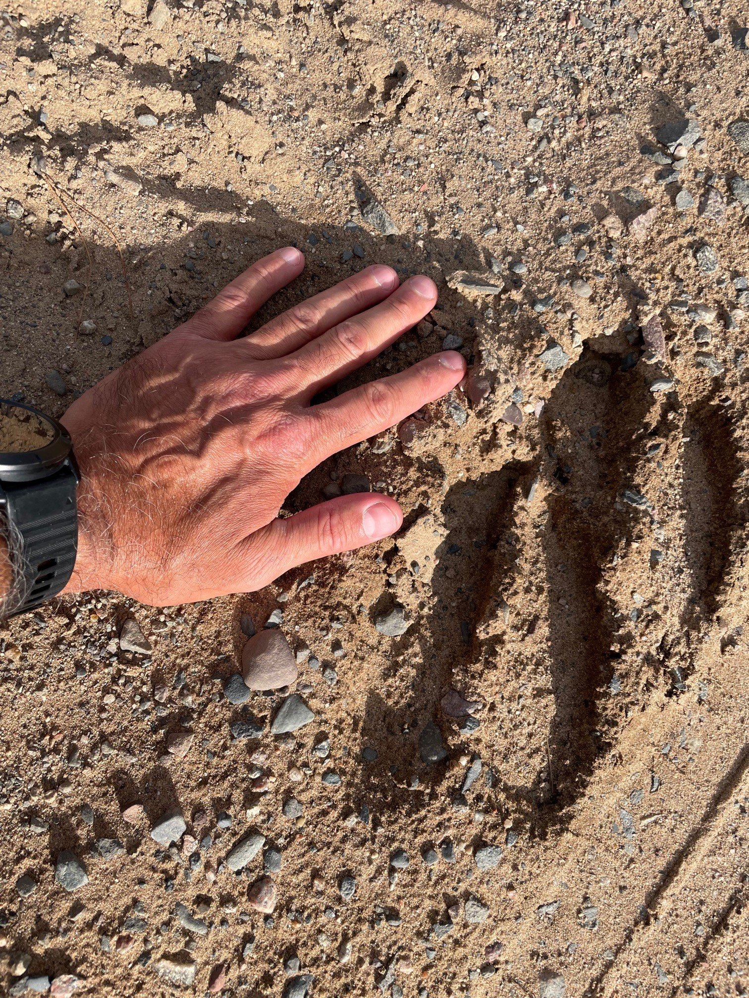
Moose tracks
K –
This is paved, and there are various opportunities to refill supplies. The start and finish are a very long way apart. You’ll need someone to transport your car, SAG vehicle, or go with a group and car drop.
E –
This is paved, and there are plenty of opportunities to refill supplies. For the sake of building the E, this route does travel along M28 for about 25 miles. I’m not a huge fan of that, but the shoulder is in good condition and many say it’s a fun ride. Of course, the Lake Superior views are magnificent. There is a gravel bike path you can pick up by Harvey and travel east. Some of that path is harder packed than other areas. I don’t think I’d do that with my 25 mm road bike tires, but I might do it with 28s. For the sake of speed however, I’d probably stick to the shoulder. This is also not a loop, and you’ll have to do some fancy car coordinating.
U –
I really enjoy this ride. It does have around 15ish miles of gravel, and yes, I used my 25mm road bike. I’m sure most people would love to swap out for larger rims. One of these days I’ll upgrade to a new Domane so I can swap out too. There is a short in and out at the far northeast tip just to get the visual of the U symmetrical. There are places to refill your supplies along the way. For the most part it’s extremely quiet. The 17 miles of road (m77) going north to Seney is the busiest section. Vehicles sometimes use that road to shuttle between M28 and US2. I ride it often during Manistique Lakes Loops. Per feedback, the State did not and does not intend to grind rumble strips into that shoulder until they make the shoulders wider.

P –
This could be a loop at 136 miles, or you can cut out 14 miles with vehicle support. I’d recommend vehicle support. Support helps with distance, but more important it helps with bike options. You’d absolutely prefer to swap out wheels/bikes during this routes gravel section. If you have vehicle support, I’d start at mile 14.5 at the intersection of Folley Hill and County Road 405. Besides the distance saved, this allows you to cover the M28 section (about 20 miles) in the morning, thereby missing most of the traffic. I’m not a fan of M28 and normally stay off it on the other rides in our events, but for the purpose of building routes that spelled out BiKE UP, a little M28 was unavoidable. From there you head up to Paradise. Be sure to fuel up your supplies because you won’t see another store for 40-50 miles. That’s also near the start of gravel, where you’ll want to swap out your wheels for larger ones, or even change bikes as you embark on about 30 miles of gravel. I did not ride the gravel in my skinny 25 mm bike tire. I used a mountain bike. If I had owned a gravel bike at the time, I would have happily used that. I really enjoy the rolling finish down to the bottom of the P. There is another couple miles of gravel on a quiet Amish farm road there, but I had zero problems on my little road tires for that one.
Secret Agenda
BiKE UP is tons of fun. Not only is it excellent training, but it’s a bit of an adventure, best shared with good friends. My hope is that so many people ride BiKE UP, that someday, when looking at Strava Heat Maps, it clearly invites people to explore the UP as they see the letters spelled across the map! That is actually the reason I created this route in the first place. The U.P. is, after all, probably one of the safest places in the country to ride a bike - so let’s save lives and tell the world to BiKE UP!
Hope to ride with you in the U.P. this summer.
James Studinger -
